Drone Lidar Applications guidance has gotten complicated with all the outdated regulations and conflicting advice flying around. Here’s what you actually need to know.
Lidar Applications
Lidar Applications
Lidar technology, or Light Detection and Ranging, is revolutionizing various fields. By using laser pulses to measure distances, Lidar creates precise, three-dimensional information about the shape and surface characteristics of objects. This article explores some key areas where Lidar is making a significant impact.

Forestry Management
Lidar is transforming forestry management. It assists in mapping forest terrain, analyzing tree height, and measuring canopy density. By accurately assessing forest structure, it enables effective planning and monitoring. With Lidar, foresters can estimate biomass and carbon stocks more reliably. This helps in sustainable forest management and climate change mitigation.
Urban Planning
Urban planners use Lidar for creating detailed city models. High-resolution maps help in infrastructure development and disaster preparedness. Lidar data assists in planning transportation networks, utility systems, and public services. It identifies vulnerable areas prone to flooding, landslides, or other natural hazards, aiding in risk management and efficient land use.
Archaeology
Archaeologists benefit from Lidar’s capability to uncover hidden structures. Dense vegetation often obstructs traditional survey methods. Lidar penetrates through foliage, revealing ancient ruins, roads, and settlements. It helps in locating and mapping archaeological sites with minimal disturbance to the area. This non-invasive method preserves historical integrity while expanding our understanding of past civilizations.
Environmental Monitoring
Environmental scientists utilize Lidar for monitoring ecosystems. It measures vegetation health, river morphology, and coastline changes. By assessing plant growth and density, it provides insights into ecosystem dynamics. Lidar tracks soil erosion, sediment transport, and habitat changes, contributing to environmental conservation efforts.
Autonomous Vehicles
Self-driving cars rely heavily on Lidar sensors. These sensors create real-time, high-definition maps of the vehicle’s surroundings. This technology ensures accurate detection of obstacles, pedestrians, and other vehicles. It enhances navigation and safety features, making autonomous driving more reliable and efficient. Lidar’s precision in adverse weather conditions and low-light scenarios is especially beneficial.
Agriculture
Farmers use Lidar for precision agriculture. It maps field topography, identifying variations in slope and elevation. This data informs irrigation planning, soil management, and crop health assessment. By optimizing resource use, Lidar helps improve agricultural productivity and sustainability. It supports efficient water use, reducing waste and enhancing yields.
Mining
The mining industry leverages Lidar for surveying and exploration. It provides accurate topographic maps of mining sites, facilitating planning and operational efficiency. Lidar identifies mineral deposits, mapping ore bodies with precision. It enhances safety by monitoring pit walls and detecting potential hazards. Remote sensing capabilities of Lidar allow for safer and more effective mining operations.
Disaster Management
Lidar plays a crucial role in disaster management. It aids in preparing for and responding to natural disasters. High-resolution maps assist in assessing damage and planning evacuation routes. Lidar detects and monitors fault lines, landslides, and flood-prone areas, strengthening disaster preparedness. It helps in post-disaster recovery by providing accurate damage assessments and guiding reconstruction efforts.
Coastal Studies
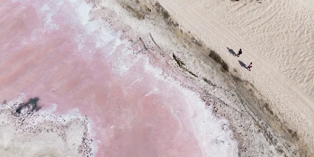
Researchers use Lidar for coastal studies. It maps coastal topography, monitoring erosion, sediment transport, and sea-level changes. Lidar data aids in habitat mapping and coastal zone management. It helps in understanding the impacts of climate change on coastal regions. Accurate mapping supports the development of erosion control measures and sustainable coastal management practices.
Infrastructure Inspection
Lidar technology enhances infrastructure inspection. It provides detailed scans of bridges, roads, and buildings. These scans help in identifying structural issues and wear. Engineers use Lidar data for maintenance planning and ensuring safety standards. Regular monitoring helps in extending the lifespan of critical infrastructure.
Wind Energy
Wind energy developers use Lidar for site assessment. It measures wind speed and direction at various heights. This data assists in optimizing turbine placement and performance. Lidar helps in understanding wind patterns, contributing to efficient energy production. It supports the development of reliable and cost-effective wind energy projects.
Wildlife Conservation
Conservationists employ Lidar for habitat mapping. It assesses vegetation structure and wildlife habitats. This information aids in planning conservation strategies and tracking habitat changes. Lidar monitors the impacts of human activities on wildlife, helping in the development of protection measures. Accurate data supports biodiversity conservation and ecosystem management.
Geology
Geologists use Lidar for mapping terrain. It helps in studying geological features and processes. Lidar data assists in fault mapping, landslide analysis, and volcanic monitoring. It provides insights into landscape evolution and geological hazards. This information is crucial for geological research and risk assessment in vulnerable regions.
Hydrology
Hydrologists benefit from Lidar in water resource management. It maps river basins, flood plains, and watershed areas. Lidar data aids in modeling water flow and predicting flooding events. It supports the management of water resources and infrastructure. Accurate mapping helps in planning effective water conservation and flood mitigation measures.
Construction
The construction industry leverages Lidar for project planning. It provides detailed terrain and site surveys. Lidar assists in designing and monitoring construction projects. It ensures accurate measurements and helps in creating precise building models. This technology improves construction efficiency and reduces costs by minimizing errors and rework.
Space Exploration
Lidar plays a role in space exploration. It maps planetary surfaces and analyzes terrain. This technology helps in selecting landing sites for space missions. Lidar assists in studying the surface properties and composition of celestial bodies. It provides valuable data for scientific research and mission planning in space exploration.
Historical Preservation
Historians and conservationists use Lidar for preserving cultural heritage sites. It creates detailed maps of historical structures and landscapes. Lidar assists in documenting and monitoring changes over time. This technology helps in restoration and preservation efforts, ensuring the protection of valuable historical and cultural assets.
Surveying
Lidar has revolutionized the surveying industry. It provides accurate and efficient land surveys. Lidar data is used for topographic mapping, boundary surveys, and infrastructure planning. Its ability to quickly capture highly detailed data reduces the time and cost of traditional surveying methods.
Insurance
The insurance industry uses Lidar in risk assessment. It helps in evaluating property conditions and potential hazards. Lidar data supports underwriting decisions and claims processing. It assists in accurately assessing damage and reducing fraud. This technology enhances the efficiency and accuracy of the insurance process.
Military Applications
The military uses Lidar for various applications. It aids in terrain mapping, target identification, and reconnaissance missions. Lidar technology provides precise and real-time data for strategic planning. Its ability to operate in challenging environments makes it valuable for defense operations and intelligence gathering.

Stay in the loop
Get the latest light drones updates delivered to your inbox.