
Drone Lidar Data Processing guidance has gotten complicated with all the outdated regulations and conflicting advice flying around. Here’s what you actually need to know.
Lidar Data Processing
Lidar, an acronym for Light Detection and Ranging, is a remote sensing technology that measures distances by illuminating a target with laser light and analyzing the reflected light. It can generate precise, three-dimensional information about the shape and surface characteristics of the Earth. Processing lidar data involves several key steps to convert raw data into usable information.
Data Acquisition
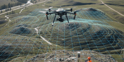
The first step in lidar data processing is acquiring the raw data. Lidar systems are often mounted on airplanes, vehicles, or drones. The platform moves over the survey area, emitting laser pulses towards the ground. These pulses reflect back and are captured by the system’s sensors. This process generates large datasets, usually comprising millions of data points known as point clouds.
Initial Data Processing
The initial processing of raw lidar data includes several sub-steps to make the data usable for further analysis. Calibration and georeferencing ensure that the data points align correctly with real-world locations. Calibration corrects any systematic errors in the measurements, while georeferencing attaches geographic coordinates to each data point.
Noise Removal
Raw lidar data often contains noise, stemming from various sources such as atmospheric interference or sensor errors. Noise removal filters out these erroneous data points. Common techniques include statistical outlier removal, where points that significantly differ from their neighbors are discarded, and spatial filters that examine the data’s spatial consistency.
Ground Point Classification
One key step is differentiating between ground and non-ground points. Ground points represent the Earth’s surface, while non-ground points might be vegetation, buildings, or other objects. Algorithms classify these points based on their height, shape, and context. This classification enables the creation of Digital Terrain Models (DTMs) that represent bare-earth elevations.
Generating Digital Elevation Models
Lidar data can generate various types of Digital Elevation Models (DEMs), including DTMs and Digital Surface Models (DSMs). A DTM provides the elevation of the ground, stripped of vegetation and man-made structures. Conversely, a DSM includes the elevations of all objects on the surface, such as trees and buildings.
Interpolation
Interpolation methods fill in any gaps or areas with sparse data to create continuous surfaces. Techniques such as Inverse Distance Weighting (IDW), Kriging, and spline interpolation use known data points to estimate unknown values, thus creating a seamless DEM.
Accuracy Assessment
The accuracy of DEMs is critical for applications such as flood modeling and urban planning. Assessment involves comparing the lidar-derived elevations with ground truth data from GPS surveys or other high-precision sources. This validation ensures that the models are accurate and reliable.
Creating Lidar Derivatives
Beyond simple elevation models, processed lidar data can produce various derivatives for specific applications.
Slope and Aspect Maps
Slope and aspect maps represent the steepness and orientation of the terrain. These maps are valuable for geological studies, hazard assessment, and land use planning. Slope is calculated as the rate of change of elevation, while aspect is the direction the slope faces.
Canopy Height Models
In forestry and vegetation studies, Canopy Height Models (CHMs) measure the height of vegetation above the ground. By subtracting the DTM from the DSM, researchers can determine the exact height of the tree canopy, providing insights into forest structure and biomass.
Change Detection
Lidar data acquired at different times can detect changes in the landscape. This process, known as change detection, involves comparing multiple datasets to identify differences. It is useful for monitoring urban development, erosion, and environmental changes.
Applications of Lidar Data
Various fields benefit from processed lidar data. In archaeology, it uncovers hidden structures beneath dense vegetation. In urban planning, it aids in designing infrastructure by providing accurate topographic information. Lidar data also improves flood risk assessments by offering high-resolution elevation data that refines hydrological models.
Utility in Agriculture
Precision agriculture leverages lidar data to assess crop health and optimize resource allocation. By analyzing the height and density of crops, farmers can make informed decisions about irrigation, fertilization, and harvesting, thus increasing yield and efficiency.
Environmental Management
Environmental scientists use lidar to study ecosystems and manage natural resources. It helps in mapping habitats, monitoring deforestation, and managing wildlife by providing detailed topographic and vegetation data.
Disaster Response
In disaster response, lidar data aids in creating accurate maps of affected areas, supporting rescue and recovery efforts. It can quickly assess damage from earthquakes, floods, and landslides, enabling timely and efficient response strategies.
Challenges in Lidar Data Processing
Despite its advantages, lidar data processing presents several challenges. The sheer volume of data requires substantial storage and computational resources. High costs involved in data acquisition and processing can also be prohibitive for some applications.
Data Complexity
The complexity of interpreting point clouds and developing accurate algorithms necessitates specialized expertise. Variability in data density due to factors such as flying altitude and terrain complexity further complicates processing efforts.
Integration with Other Data
Integrating lidar data with other geospatial datasets like aerial photographs or satellite imagery enriches analysis but also introduces alignment and compatibility issues. Ensuring consistent and accurate merging of these datasets is critical for obtaining reliable results.
Future Prospects of Lidar Technology
Continuous advancements in lidar technology promise to enhance its capabilities and accessibility. Improvements in sensor technology, data processing algorithms, and machine learning integration are likely to make lidar more versatile and cost-effective.
Automated Processing
Automation in lidar data processing could reduce the need for manual intervention, making the technology more efficient. Automated classification and feature extraction algorithms will speed up data processing and expand lidar’s applications.
Miniaturization
The trend towards smaller, lighter lidar systems could facilitate their deployment on a wider range of platforms, including autonomous vehicles, small drones, and handheld devices. This miniaturization opens new possibilities for real-time data acquisition and analysis.
Enhanced Data Fusion
Combining lidar data with other sensor data, such as multispectral or hyperspectral imagery, will provide richer insights. Enhanced data fusion techniques will lead to more comprehensive environmental monitoring and resource management solutions.


Stay in the loop
Get the latest light drones updates delivered to your inbox.