
Drone Lidar in Archaeology guidance has gotten complicated with all the outdated regulations and conflicting advice flying around. Here’s what you actually need to know.
Lidar in Archaeology
Lidar in Archaeology
Lidar, which stands for Light Detection and Ranging, has revolutionized various fields, including archaeology. This remote sensing technology measures distances by illuminating targets with laser light and analyzing the reflected light. It creates highly accurate, three-dimensional maps of the surface topography, uncovering hidden structures and features.

How Lidar Works
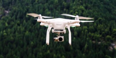
Lidar systems send laser pulses from an aircraft, drone, or ground-based devices. These pulses bounce off surfaces and return to the receiver. The system measures the time taken for the light to return, calculating the distance to the target. Sophisticated software then generates detailed topographic maps from this data.
The Benefits of Lidar in Archaeology
Lidar offers numerous benefits to archaeologists. It enables them to survey large areas quickly, often revealing features that traditional methods miss. Dense vegetation or urban development can obscure sites from other forms of aerial photography or ground surveys. However, lidar can penetrate tree canopies and map the underlying ground surface, exposing hidden archaeological features.
Early Uses of Lidar in Archaeology
The use of lidar in archaeology began in the late 20th century. Early adopters quickly recognized its potential for discovering lost or hidden sites. One of the first successful applications occurred in Belize, Central America. Researchers used the technology to map ancient Maya cities hidden beneath the jungle. They uncovered roads, buildings, and other structures, providing insights into how these civilizations were organized.
Case Studies Highlighting Lidar’s Impact
Caracol, Belize
In 2009, a team of archaeologists used lidar to survey Caracol, one of the largest Maya cities. The dense jungle made traditional mapping slow and challenging. Lidar revealed extensive networks of roads, terraces, and buildings. This data helped researchers understand the city’s scale and complexity, which was far greater than previously thought.
Angkor Wat, Cambodia
In Cambodia, lidar unveiled new aspects of the Angkor Wat temple complex. In 2012 and 2015, archaeologists discovered previously unknown urban structures and water systems surrounding the temples. These findings challenged existing theories about the size and organization of the ancient Khmer Empire’s capital.
Scottish Highlands
In Scotland, lidar has identified numerous prehistoric sites hidden within the highlands. Researchers have discovered ancient settlements, forts, and field systems. Lidar has provided a clearer picture of human activity in this rugged terrain over thousands of years.
Technical Aspects of Lidar
The technology relies on precise equipment and sophisticated data processing techniques. A typical lidar system includes a laser, a scanner, and a specialized GPS receiver. The laser emits rapid pulses of light, while the scanner directs these pulses over the survey area. The GPS data ensures accurate positioning of each measurement point.
Data processing involves filtering and interpreting the raw data to produce usable maps. This step removes noise, such as reflections from vegetation or buildings, to reveal the ground surface. Advanced software analyzes the clean data, producing detailed images and models of the terrain.
Lidar and Predictive Modelling
Lidar data can also be used in predictive modeling. Archaeologists can identify patterns and correlations in the landscape that hint at potential locations of undiscovered sites. By analyzing factors like elevation, slope, and proximity to water sources, researchers can prioritize areas for further investigation.
Limitations of Lidar
Lidar is not without limitations. It can be expensive, requiring sophisticated equipment and software. In some environments, like areas with heavy tree cover or urban settings with complex structures, data interpretation can be challenging. Additionally, lidar cannot provide information about buried features or materials; it only maps surface topography.
Combination with Other Technologies
Combining lidar with other technologies can enhance its effectiveness. Ground-penetrating radar (GPR) and magnetometry, for instance, can detect subsurface features that lidar misses. Aerial photography and satellite imagery can complement lidar data, providing a more comprehensive view of the survey area.
Future of Lidar in Archaeology
The future of lidar in archaeology looks promising. Advances in technology are making lidar more accessible and affordable. New developments in drone technology are expanding its use in remote or difficult-to-reach areas. As software continues to improve, data processing will become more efficient, yielding better insights.


Stay in the loop
Get the latest light drones updates delivered to your inbox.